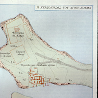
Plan of Ágios Kosmás
Item
File name
sackett_002 See all items with this value
Title
Plan of Ágios Kosmás See all items with this value
Description
This image shows a map with an aerial view of an archaeological site on a peninsula, with a ground plan designated in orangish-red over the green ground. There is Greek text above the map in a paragraph format as well as a title: Η ΧΕΡΣΟΝΗΣΟΣ ΤΟΥ ΑΤΙΟΥ ΚΟΣΜΑ (The Peninsula of Agios Kosmas). See all items with this value
Place name
Ágios Kosmás, Ákra (point) See all items with this value
Subject
Archaeological Site
Notes
This appears to be the Early-Middle Bronze Age site in Attica excavated by George Mylonas. Its Classical name was Akra Kolias, but today it is within the Athenian suburb of Euonymeia. The Greek text mentions "remains of the Middle Helladic period" and G. Mylonas.
Date photographed
February, 1975
